DCS Reference: Ships, Western
Many carrier aircraft have somewhat contradictory definitions, or definitions of unclear value, as far as their carrying capacity. They may list only having 4 parking spots and a max number of aircraft or helicopters, in one sense, but then have coordinates set for over a dozen different parking spots on the deck. The blocks below distinguish between these two by calling them “nominal” and “defined” limits, where the nominal parking limit at most seems to correlate to how many different aircraft can be designated as “start on runway” in the mission editor.
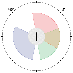
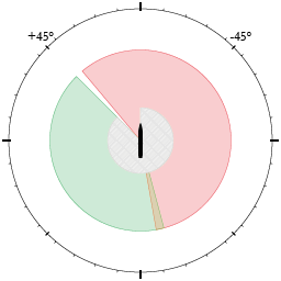
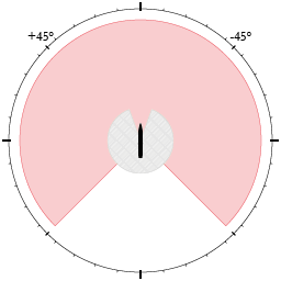
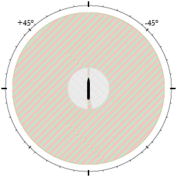
The defensive arcs show the areas around the ship where specific defensive systems have full range of movement. This does not mean that areas that are not covered are safe — rather that the ship systems will be limited in their effectiveness because ship decks, conning towers, or bridges are in the way. However, given enough elevation, they can usually shoot over such obstructions, and only low-altitude skimming creates the coverage gaps demonstrated. In addition, depending on the guidance system of the weapon, they may be lofted above obstacles if the target is far enough away, which means that the “safe zone” only exists at low altitude and at close range.
Up to four range layers are shown in the arc sketches: close-range protection (from CIWS and simular systems); short-range protection, usually from IR-guided missiles; medium-range protection, usually from less advanced radar missiles; and long-range protection.
Ships
Arleigh Burke-class Destroyer
DDG-112 Michael Murphy[1]
USS Arleigh Burke IIa (Supercarrier)
![]()
![]()
Nimitz-class Carrier
Nimitz subclass
| Mission Editor Unit | Function | Stores | Range / Symbol | |
|---|---|---|---|---|
| CVN-70 Carl Vinson | Carrier | 3× 8× RIM-7 Sea Sparrow 4× 1550× 20mm Phalanx |
Detection: 0–16.2nm / 0–30km Detection alt.: 0–87,200ft / 0–26,600m[2] Engagement: 0–8.1nm / 0–15km Engagement alt.: 0–45,300ft / 0–13,800m | |
| Hit points | 7,300 | Max speed | 15.4m/s (29.9kts, 55.5km/h) | Defensive arcs |
| Sensor limits | Surface radar: 360° horizontal × -5°–+10° vertical; 12s scan time. SS lock-on: 21.1nm / 39km. Notch: <15m/s (29kts, 54km/h) vrad. AA Radar: 360° horizontal × -15°–+60° vertical; 1s scan. AA lock-on: 13.8nm / 25.5km. Notch: <10m/s (19kts, 36km/h) vrad. No target size limit is defined that would affect its ability to engage incoming air weapons. |
|||
| Carrying capacity | 13 defined aircraft parking spots. 5 defined helicopter parking spots 2+2 catapults (1+1 can be used safely in parallel). 4 nominal spawn points. 72 aircraft + 6 helicopter nominal capacity. | |||
| Notes | ||||
| Acts as a warehouse to deliver stores to other units and to landed aircraft. Per the internal definitions, it cannot re-arm its own weapon stores once depleted. | ||||
| Available to | ||||
Theodore Roosevelt sub-class (Basic)
| Mission Editor Unit | Function | Stores | Range / Symbol | |
|---|---|---|---|---|
| CVN-74 John C. Stennis | Carrier | 2× 8× RIM-7 Sea Sparrow 3× 1550× 20mm Phalanx |
Detection: 0–16.2nm / 0–30km Detection alt.: 0–87,200ft / 0–26,600m Engagement: 0.2–8.1nm / 0.4–15km Engagement alt.: 15–49,200ft / 5–15,000m | |
| Hit points | 7,300 | Max speed | 15.4m/s (29.9kts, 55.4km/h) | Defensive arcs |
| Sensor limits | Surface radar: 360° horizontal × -5°–+10° vertical; 12s scan time. SS lock-on: 21.1nm / 39km. Notch: <15m/s (29kts, 54km/h) vrad. AA radar: 360° horizontal × -15°–+60° vertical; 1s scan. AA radar lock-on: 13.8nm / 25.5km. Notch: <10m/s (19kts, 36km/h) vrad. Mk95 trackers can engage 4 targets at a time; lock-on time 2.5s. Size limit: 0.1m².[3] |
|||
| Carrying capacity | 19 defined aircraft parking spots. 8 defined helicopter parking spots 2+2 catapults (1+1 can be used safely in parallel). 4 nominal spawn points. 72 aircraft + 6 helicopter nominal capacity. | |||
| Notes | ||||
| Acts as a warehouse to deliver stores to other units and to landed aircraft. Per the internal definitions, it cannot re-arm its own weapon stores once depleted.
The engagement limits only apply to the Mk95 trackers used to guide RIM-7 Sea Sparrows. | ||||
| Available to | ||||
Theodore Roosevelt sub-class (Supercarrier)
CVN-71 Theodore Roosevelt
CVN-71 Theodore Roosevelt (supercarrier)
![]()
![]()
CVN-72 Abraham Lincoln
CVN-72 Abraham Lincoln (supercarrier)
![]()
![]()
CVN-73 George Washington
CVN-73 George Washington (supercarrier)
![]()
![]()
CVN-75 Harry S. Truman
CVN-75 Harry S. Truman (supercarrier)
![]()
![]()
Oliver Hazard Perry-class Frigate
| Mission Editor Unit | Function | Stores | Range / Symbol | |
|---|---|---|---|---|
| Oliver Hazard Perry class | Guided-missile frigate | 1× 24× RIM-66 Standard Missile 2 1× 1550× 20mm Phalanx 4× 100× 12.7mm M2 2× 230× 25mm Bushmaster 1× 180× 76mm Mk75 1× 16× RGM-84 Harpoon |
Detection: 0–80.1nm / 0–150km Detection alt.: 0–343,500ft / 0–104,700m[2] Engagement: 0–54.0nm / 0–100km Engagement alt.: 0–229,000ft / 0–69,800m | |
| Hit points | 2,300 | Max speed | 14.9m/s (29.0kts, 53.6km/h) | Defensive arcs |
| Sensor limits[4] | Surface radar: 360° horizontal × -5°–+10° vertical; 12s scan time. SS lock-on: 18.2nm / 33.6km. Notch: <15m/s (29kts, 54km/h) vrad. AA radar: 360° horizontal × -15°–+60° vertical. AA lock-on: 119.3nm / 221km. Notch: <15m/s (29kts, 54km/h) vrad. Mk92 tracker can engage 1 targets at a time; lock-on time 10s. No target size limit is defined that would affect its ability to engage incoming air weapons. |
|||
| Carrying capacity | 1 defined helicopter parking spots 2 helicopter nominal capacity. | |||
| Notes | ||||
| Acts as a warehouse to deliver stores to other units and to landed aircraft. Per the internal definitions, it cannot re-arm its own weapon stores once depleted.
The Mk13 launch rail has a nominal readying time of 12s between missiles, but this is almost always swallowed up by the locking time and guidance of previous missiles, unless the enemy target is at very close range (in which case missiles are often not used at all). Is internally defined to allow attacks against targets up to 65.8nm / 120km away, presumably to allow for Harpoon targeting. | ||||
| Available to | ||||
Tarawa-class Amphibious Assault Ship
LHA-1 Tarawa
KHA-1 Tarawa
![]()
![]()
Ticonderoga-class Cruiser
| Mission Editor Unit | Function | Stores | Range / Symbol | |
|---|---|---|---|---|
| Ticonderoga class | Guided-missile cruiser | 2× 45× RIM-66 Standard Missile 2 2× 1550× 20mm Phalanx 3× 100× 12.7mm M2 2× 230× 25mm Bushmaster 2× 180× 127mm Mk45 2× 4× RGM-84 Harpoon 2× 16× BGM-109 Tomahawk |
Detection: 0–80.1nm / 0–150km Detection alt.: 0–343,500ft / 0–104,700m[2] Engagement: 0–54.0nm / 0–100km Engagement alt.: 16.5–98,400ft / 5–30,000m | |
| Hit points | 2,700 | Max speed | 15.4m/s (29.9kts, 55.4km/h) | Defensive arcs |
| Sensor limits[4] | Surface radar: 360° horizontal × -5°–+10° vertical; 12s scan time. SS lock-on: 18.9nm / 35km. Notch: <15m/s (29kts, 54km/h) vrad. AA radar: 360° horizontal × -15°–+60° vertical. AA lock-on: 119.3nm / 221km. Notch: <15m/s (29kts, 54km/h) vrad. AEGIS trackers can guide 2 missiles per target at 9 targets at a time; lock-on time 2s. Target size limit: 0.1m².[3] |
|||
| Carrying capacity | 1 defined helicopter parking spots 2 helicopter nominal capacity. | |||
| Notes | ||||
| Acts as a warehouse to deliver stores to other units and to landed aircraft. Per the internal definitions, it cannot re-arm its own weapon stores once depleted.
Is internally defined to allow attacks against targets up to 243nm / 450km away, presumably to allow for Harpoon and Tomahawk targeting. | ||||
| Available to | ||||
Systems
Phalanx CIWS
RIM-7 Sea Sparrow
RIM-66 Standard Missile 2
RIM-116 Rolling Airframe Missile
Notes
- ↑ Hull number 112 is supposed to be a single-CIWS variant, but the model in DCS features both a fore and an aft CIWS system.
- ↑ 2.0 2.1 2.2 This unit uses an antiquated and simplified sensor definition based on angles to define its search altitude, as opposed to more moden explicit limits.
- ↑ 3.0 3.1 Compare, effective target sizes:
- Small: Vikhr: 0.012m² · AGM-114: 0.015m² · AGM-122: 0.03m² · BGM-71 0.033m²
- Medium: AGM-88 / C-701 / LD-10: 0.05m² · Kh-23 / Kh-25 / Kh-66: 0.06m² · AGM-154 0.05–0.062m³ · AGM-65 / Rb-75: 0.063m² · LS-6: 0.07m² · C-802 / AGM-45: 0.09m²
- Large: GB-6 / Kh-35: 0.1m² · Kh-58 / Rb-04 / Rb-05 / Rb-15 / Sea Eagle: 0.12m² · AGM-84: 0.08–0.17m² · AGM-86 / Kh-65: 0.17m² · Kh-29: 0.18m² · Kh-59: 0.2m² · Kh-31: 0.3m² · BK-90: 0.4m²
- OMFG: ADM-141: 0.9–1.2m² · Kh-22: 1.82m² ·
- ↑ 4.0 4.1 According to the measuring distance and lock-on distance coefficient in the data files, this system can actually detect and lock targets beyond its stated in-effect detection range. This is because it uses stats of a land-based system that could conceivably have distributed and data-linked detectors that would necessitate such capabilities in its simulation.


