Normandy 1944
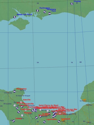
For all the DCS World propellerheads, this is a terrain module to provide an appropriate backdrop for all those old-timey fights. The Normandy 1944 map is exactly what one would expect: a recreation of the stretch of coast covered by the D-Day invasion — from Cherbourg to Le Havre — and enough inland, channel, and bits of Kent, Sussex, and Hampshire to provide targets and starting locations on the British side as well. In total, the modeled part of the map covers some 170×190 nautical miles.
Currently, the time frame is almost as fixed as the geographic location: the map very specifically depicts the summer of 1944, with area-appropriate vehicles and season-appropriate greenery. There have been mumblings about making it possible to also play at winter and to, if not change the towns and buildings, then at least make trains and cars look a bit more modern if a later date is specified. So far, though, nothing has come of it.
The map obviously offers a lot of English Channel to cross, as well as the steep cliffs at either side, but beyond those obstacles, it is almost entirely rolling hills filled with bocages — fields surrounded by tree rows, with the occasional forest thrown in for good measure. Small towns and hamlets are plentiful, many with name you will obviously recognise from history. The airport distribution is almost absurd by modern standards, but actually leaves a fair number out — perhaps unsurprisingly as almost any open area could quickly be turned into a temporary airfield. At the same time, should one try to use the map for any modern aircraft, the realisation quickly sinks in that most of these airports cannot be used by most modern planes. The runways are simply too short; their approaches too cluttered with trees and church towers and chimneys; and they lack any and all navigation aid one would normally expect… including runway lights.
Links and files
- Compact airfield information (see also kneeboard mods).
- DCS: Normandy 1944 Map in the DCS shop.
Related DCS modules
- Charnwood for P-51D
- Operation Epsom for Spitfire LF Mk. IX
- WWII Assets Pack
More information
- Invasion of Normandy on wikipedia.
| DCS World | |
|---|---|
| Terrain modules |
Caucasus · The Channel · Mariana Islands · Nevada Test and Training Range (NTTR) · Normandy 1944 · Persian Gulf · Syria |


